Genesys International Corporation: India's Digital Twin Revolution
I. Introduction & Episode Roadmap
Picture this scene: It's March 2024, and in the gleaming boardroom of Mumbai's Brihanmumbai Municipal Corporation, municipal officials gather around a massive screen displaying something extraordinary—a perfect 3D digital replica of their entire city, every building, every street corner, every drainage pipe rendered in photorealistic detail. This moment marks the signing of a Rs 155 crore contract with Genesys International Corporation to develop a 3D city model and map stack for Mumbai, representing a significant development in applying advanced mapping technology to develop a highly accurate Mumbai 3D model. For a company that started when GPS was still military-only technology, this represents the culmination of an improbable three-decade journey from analog photogrammetry to digital twin dominance.
The question that drives today's narrative isn't just how an Indian company built mapping capabilities when the government held a monopoly on cartographic data—it's how Genesys International positioned itself to become the architect of India's digital infrastructure revolution at precisely the moment when smart cities, autonomous vehicles, and urban digital twins became national priorities. This is the story of perfect timing meeting relentless preparation, of building capabilities for a market that didn't yet exist, and ultimately, of creating what would become the foundation for India's geospatial awakening.
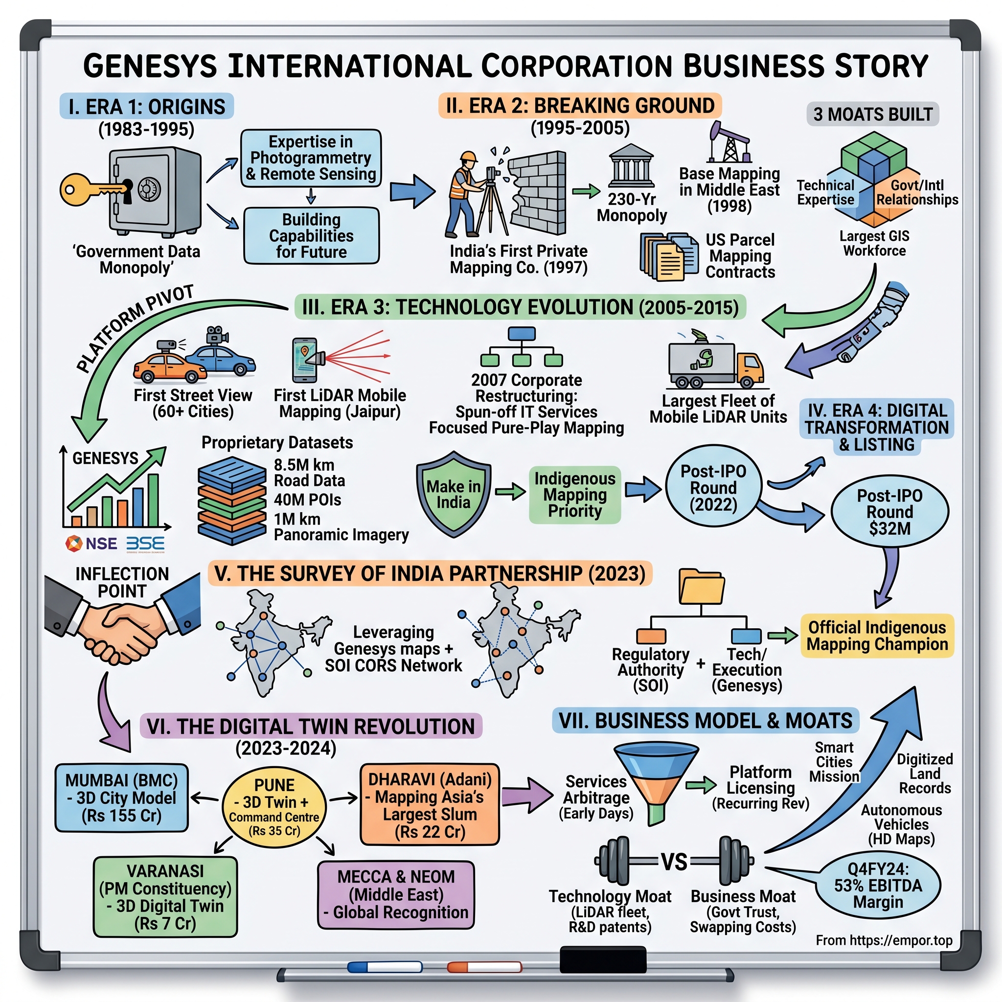
Incorporated on January 28, 1983, Genesys International's journey spans four distinct eras: the monopoly-breaking years when private mapping was unthinkable, the technology transition from analog to digital, the platform pivot during the smartphone revolution, and finally, the current digital twin dominance that has attracted everyone from Prime Minister Modi to the Adani Group as clients. What makes this story particularly compelling for investors is how the company transformed from a services arbitrage play into a data and platform powerhouse—all while navigating regulatory minefields, global tech competition, and the peculiarities of selling to Indian government entities.
II. Origins & The Early Vision (1983-1995)
The India of 1983 was a vastly different place—License Raj ruled supreme, computers were luxury items locked in air-conditioned rooms, and the very idea of private companies creating maps was not just unusual, it was essentially illegal. When Genesys International Corporation Limited was incorporated on January 28, 1983, the founders weren't thinking about digital twins or autonomous vehicles. They were simply recognizing an inefficiency: India's spatial data was locked in government vaults, inaccessible to businesses that desperately needed it.
Consider the regulatory environment they faced. The Survey of India, established in 1767, held absolute monopoly over mapping activities. The colonial-era National Map Policy treated cartographic data as a matter of national security. Private companies couldn't legally acquire aerial photographs, couldn't create detailed maps of cities, and certainly couldn't sell geographic data. It was into this seemingly impossible market that Genesys ventured, initially focusing on what little was permissible—digitizing existing government maps and providing GIS consulting services to public sector enterprises.
The pre-liberalization period from 1983 to 1991 was essentially a waiting game. The company survived by becoming experts in photogrammetry—the science of making measurements from photographs—and remote sensing technologies. They built capabilities that had no immediate commercial application in India, training engineers on equipment they couldn't legally use for domestic projects. It was a classic case of what venture capitalists today would call "building for the future market," except the founders had no idea when, or if, that market would ever materialize.
Then came 1991. Economic liberalization didn't immediately change mapping regulations, but it cracked open the door. Foreign companies needed Indian partners who understood local geography. Infrastructure projects required detailed surveys. The telecom revolution was beginning, and someone needed to map where to place those cell towers. Genesys had spent eight years preparing for this moment, accumulating expertise in a field where expertise was rare. By the time the company "officially" established itself in 1995 as a full-fledged mapping services provider, it had already built the technical foundation that would make it India's mapping pioneer.
The genius wasn't in predicting that India would eventually liberalize its mapping policies—many expected that. The genius was in building world-class photogrammetric capabilities during the monopoly years, ensuring that when the market opened, Genesys wouldn't just be ready; it would be years ahead of any potential competitor. This pattern—building capabilities before the market exists—would become the company's defining strategic playbook.
III. Breaking Ground: India's First Private Mapping Company (1995-2005)
The year 1997 marked a watershed moment in Indian cartographic history, though few recognized it at the time. Established in 1997, Genesys became India's first non-government company to start photogrammetric mapping, essentially breaking a 230-year government monopoly. How they pulled this off is a masterclass in regulatory navigation and strategic positioning.
The company didn't directly challenge the Survey of India's authority. Instead, they found the gaps—areas where the government either couldn't or wouldn't operate efficiently. International clients needed Indian geographic data for infrastructure projects but couldn't navigate the bureaucratic maze of government permissions. State governments wanted GIS systems but lacked the technical expertise to implement them. Telecom companies rolling out networks needed detailed city maps updated more frequently than the government's decade-long survey cycles could provide. Genesys positioned itself as the bridge, the translator, the enabler—never the challenger.
The company executed base mapping in Middle East using aerial photography in 1998, a seemingly small detail that reveals enormous strategic importance. By working internationally first, Genesys built credibility, generated hard currency revenues, and most importantly, developed capabilities that would eventually be desperately needed in India. They were essentially beta-testing their services in markets where regulations were clearer, preparing for the day when India would open up.
The early client wins read like a who's who of India's infrastructure boom. Utility companies needed to map their assets. American states outsourced parcel mapping to Indian firms, and Genesys grabbed multi-million dollar contracts. With a team of over 2,000 professionals, the company built one of the largest geospatial engineering workforces outside of government agencies. But unlike typical IT services companies that competed on cost, Genesys competed on unique capability—they were often the only private company in India that could execute certain types of mapping projects.
The technology stack they built during this period was remarkable for its foresight. While competitors were still using paper maps and manual surveying, Genesys invested heavily in digital photogrammetry workstations, GPS equipment (when it became available for civilian use), and more importantly, in training engineers to use these tools. They created what was essentially India's first private mapping assembly line—raw aerial photographs went in one end, and detailed, georeferenced digital maps came out the other.
By 2005, the company had quietly built three moats that would prove insurmountable for new entrants: technical expertise in photogrammetry that took years to develop, relationships with both government agencies and international clients that provided steady revenue, and most importantly, a massive trained workforce that understood both the technology and the unique requirements of Indian geography. The foundation was set for the next phase—becoming India's answer to Google Street View.
IV. The Street View Pioneer & Technology Evolution (2005-2015)
The story of how Genesys became India's first company to capture 360-degree street view for more than 60 cities in India begins with a prescient observation: Google Maps had launched in 2005, and it was only a matter of time before they came to India. Rather than wait to be disrupted, Genesys decided to disrupt itself first.
The technical challenge was staggering. Creating street-level imagery required custom-built vehicles equipped with 360-degree cameras, GPS units, and inertial measurement systems. The logistics were even more complex—navigating Indian traffic, dealing with narrow gullies where cars couldn't go, handling permissions from local authorities who had never encountered such requests. The company became India's first Company to start 3D LiDAR Mobile Mapping and created 3D Building Models of an entire city in India (Jaipur), a project that required capturing and processing millions of data points to create accurate three-dimensional representations.
But the real innovation wasn't technical—it was strategic. Genesys realized that owning street-level imagery and 3D data of Indian cities would create an almost impossible moat for competitors to cross. The cost and complexity of capturing this data meant that even deep-pocketed global tech giants would think twice before replicating it. By moving first and fast, Genesys essentially claimed digital ownership of India's urban geography.
The 2007 corporate restructuring deserves special attention. During the year 2006-07, the Information Technology and Engineering Business Division of the Company was segregated/transferred and demerged into a separate Company i.e. M/s GI Engineering Solutions Ltd., through a Scheme of Arrangement made effective from 1st October, 2007. This wasn't just financial engineering—it was strategic focus. By spinning off the IT services business, management signaled that Genesys would be a pure-play mapping company, not another generic IT services firm.
The 2008 financial crisis tested this strategy. Clients cut budgets, international projects dried up, and the company faced its first existential crisis since liberalization. Many Indian IT companies diversified during this period, adding any service that could generate revenue. Genesys did the opposite—they doubled down on mapping, used the downturn to hire talent cheaply, and invested in next-generation LiDAR technology when equipment prices crashed. By 2010, when markets recovered, they had the country's largest fleet of mobile mapping units including High Definition (LiDAR) scanning systems.
The period from 2010 to 2015 saw Genesys building what would become its most valuable asset—comprehensive street-level data of urban India. Over 250,000 linear km, spanning 65 major cities across India, of street-level 360-degree panoramic imagery data acquisition was completed. This wasn't just data collection; it was the creation of a proprietary dataset that would become invaluable as India's smart city ambitions took shape.
V. The Digital Transformation & Public Listing Era (2015-2022)
The 2015-2022 period represents Genesys's transformation from a mapping services company to a platform and data provider—a shift as dramatic as Netflix's evolution from DVD rental to streaming. The company recognized that in the age of smartphones and IoT devices, static maps were becoming commoditized. The future belonged to dynamic, real-time, three-dimensional representations of the world.
As a publicly listed company on both NSE and BSE, Genesys now faced quarterly scrutiny from investors who didn't always understand why the company was investing heavily in building capabilities that had no immediate market. Mobile LiDAR systems, aerial mapping platforms, and armies of data processing engineers represented massive capital expenditure with uncertain returns. The bear case was simple: Google would eventually map India for free, making Genesys obsolete.
Management's response revealed deep strategic thinking. Google might map India's roads, but would they create centimeter-accurate 3D models of every building? Would they provide specialized datasets for telecom tower placement, utility mapping, or disaster management? Would they work with Indian government agencies requiring data sovereignty? Genesys wasn't competing with Google Maps; they were building the specialized, high-accuracy geospatial infrastructure that India's digital transformation would require.
The company developed highly accurate, fully navigable road datasets covering 8.5 million kilometres, 40 million points of interest (POIs) and addresses, and an unprecedented one million kilometres of 360-degree panoramic imagery. This wasn't just about quantity—each data point was verified, updated regularly, and enriched with local context that global platforms couldn't capture. When a Mumbai municipal engineer needed to know the exact height of buildings for flood modeling, or when a telecom company needed line-of-sight analysis for 5G tower placement, Google Maps wasn't the answer—Genesys was.
The "Make in India" initiative launched in 2014 provided unexpected tailwinds. Suddenly, having indigenous mapping capabilities wasn't just nice to have—it was a matter of national priority. The government's Digital India program needed Indian companies to provide critical digital infrastructure. Genesys, with its two-decade head start and massive datasets, was perfectly positioned to benefit from this shift in sentiment from "why not just use Google?" to "we need our own mapping capabilities."
The company's latest funding round was a Post IPO round on June 15, 2022 for $32M, with 9 investors participating including Malabar Investments. This capital injection wasn't about survival—the company was profitable. It was about acceleration, about building capabilities for the next phase of growth. The investors weren't betting on Genesys competing with global tech giants; they were betting on the company becoming India's geospatial infrastructure backbone.
VI. The Inflection Point: Survey of India Partnership (2023)
November 2023 will likely be remembered as the moment when Genesys transitioned from a successful niche player to a strategic national asset. The strategic alliance with Survey of India to create digital twins of major cities and towns, leveraging Genesys's highly accurate navigable maps and SOI's CORS network, aligned with India's National Geospatial Policy 2022, which promotes self-reliance in geospatial data production and usage.
To understand the magnitude of this partnership, consider what it meant: the very organization that had held a monopoly on mapping for over 250 years was now partnering with a private company as an equal. This wasn't a vendor relationship or a service contract—it was a strategic alliance to build India's geospatial future together. The Survey of India brought regulatory authority and the CORS (Continuously Operating Reference Stations) network; Genesys brought technology, execution capability, and private sector efficiency.
SOI's Continuously Operating Reference Stations (CORS) network, comprising 902 stations across all states and Union Territories, provides real-time, high-precision positioning data. By integrating this with Genesys's mapping capabilities, the partnership created something neither could achieve alone—a real-time, highly accurate, continuously updated digital representation of India's urban landscape. This wasn't just about making better maps; it was about creating the foundation for India's digital twin infrastructure.
The partnership also solved Genesys's biggest challenge—regulatory uncertainty. Every mapping project in India required navigating complex permissions, security clearances, and bureaucratic approvals. With Survey of India as a partner, these barriers essentially disappeared. Genesys could now operate with the authority of a national mapping agency while maintaining the agility of a private company.
Sajid Malik, chairman and managing director of Genesys International, expressed his pride: "We are proud to join forces with Survey of India to create a Digital Twin of Indian cities that will serve as a cornerstone for India's development. We are excited that India's foremost mapping authority is playing the nodal role in the growth of this sunrise digital infrastructure." This wasn't corporate speak—it was recognition that Genesys had achieved something remarkable: official recognition as India's private sector mapping champion.
The implications rippled through the market immediately. Government contracts that had been stuck in bureaucratic limbo suddenly moved forward. State governments that had been hesitant to work with private mapping companies now had official cover. International clients who needed India data but worried about regulatory compliance now had a clear path forward. The Survey of India partnership wasn't just a contract—it was a government seal of approval that transformed Genesys from a vendor into a partner in nation-building.
VII. The Digital Twin Revolution & Mega Contracts (2023-2024)
The eighteen months following the Survey of India partnership saw Genesys win a cascade of transformative contracts that validated its digital twin strategy. Each project tells a different story about India's urban future, but together they paint a picture of a company at the center of the country's smart city revolution.
The Mumbai contract worth Rs 155 crore with the Brihanmumbai Municipal Corporation to develop a 3D city model included development, implementation, and upkeep of a highly accurate 3D city model and map stack for Mumbai with updates for 3 years. This wasn't just about mapping India's financial capital—it was about creating a template for how megacities could use digital twins for everything from flood management to traffic optimization. The technology stack was staggering: LiDAR-equipped aircraft captured the city from above, mobile mapping vehicles covered every street, and backpack-mounted sensors mapped narrow alleys where vehicles couldn't go.
Then came the PM's constituency. Prime Minister Narendra Modi commissioned Genesys to develop a 3D Digital Twin of Varanasi, leveraging the company's New India Map stack, with an order value of INR 7 crores to capture the city's physical features, processes, and relationships in intricate detail. The symbolism was unmistakable—India's most important political leader was endorsing Genesys's technology for his own constituency. The project covered an extensive area of 160 square kilometers, capturing not just the modern city but also the ancient ghats, temples, and narrow medieval streets that define Varanasi's character.
The Pune project added another dimension. Worth INR 35 Crores, this wasn't just about creating a 3D map—it was about integration. For the first time in India, a 3D Digital Twin would be seamlessly integrated with a Command and Control Centre, incorporating various IoT sensors, providing real-time data insights and actionable intelligence to authorities. Traffic sensors, air quality monitors, and flood gauges would feed real-time data into the digital twin, creating a living, breathing model of the city.
But perhaps the most audacious project was Dharavi. The contract, valued at Rs 22 crore (excluding GST), awarded by Adani Group's Portsmouth Buildcon Private Ltd, involved creating a digital twin of Asia's largest slum. This wasn't just technically challenging—mapping informal settlements with no addresses, irregular structures, and constant change—it was socially and politically sensitive. The Dharavi redevelopment, one of India's most ambitious urban renewal projects, would be planned and executed using Genesys's digital twin as the foundation.
The Middle East expansion deserves special attention. Prestigious 3D Digital Twin mapping contracts for Mecca and the NEOM project in Saudi Arabia showcased that the technology was among the best globally. Mapping Islam's holiest site required not just technical excellence but also cultural sensitivity and absolute precision—millions of pilgrims' safety during Hajj depended on accurate crowd flow modeling based on Genesys's data. The NEOM project, Saudi Arabia's $500 billion futuristic city, chose an Indian company over global competitors for its digital twin infrastructure.
VIII. Business Model & Financial Evolution
The financial evolution of Genesys International reads like a textbook case study in transitioning from a services to a platform business model, except the textbook hasn't been written yet because few companies have successfully made this pivot in the B2G (business-to-government) space.
In the early days, the revenue model was straightforward services arbitrage: collect geographic data, process it using lower-cost Indian engineers, deliver maps to international clients. Gross margins were decent (40-50%) but not spectacular, growth was linear with headcount, and working capital requirements were substantial because government clients paid slowly. It was a good business but not a great one.
The platform transition began around 2015 but accelerated dramatically post-2020. Instead of just delivering maps as a service, Genesys started licensing access to its datasets. A telecom company planning network expansion could subscribe to continuously updated 3D city models. An e-commerce company optimizing delivery routes could access POI databases. Urban planners could use the digital twin platform for simulations. The beauty of this model was that the marginal cost of serving additional customers approached zero while the value delivered remained high.
The Q4FY24 revenue of Rs. 70.11 crore marked a 48% rise from Rs. 47.39 crore in the same quarter the previous year. But the real story wasn't top-line growth—it was margin expansion. EBITDA margin for the quarter was 53.11%, an improvement from 37.56% the previous year. This wasn't just operational efficiency; it was the platform model kicking in. Once the data was captured and processed, selling additional licenses or subscriptions required minimal incremental cost.
The government contract dynamics created an interesting financial rhythm. Large contracts like Mumbai's ₹155 crore deal were typically structured with upfront payments for data capture, followed by annual maintenance and update fees. This created lumpy revenue recognition but predictable long-term cash flows. The three-year update clauses in most contracts meant that Genesys essentially had recurring revenue disguised as project revenue—a characteristic that public markets often undervalue.
International revenue grew from virtually nothing to becoming a meaningful contributor, but not in the way most Indian IT companies expanded globally. Instead of setting up offices in the US or Europe to chase enterprise clients, Genesys focused on other emerging markets with similar challenges—Middle East cities needed digital twins for smart city initiatives, Southeast Asian countries required mapping for infrastructure projects. The competition from Google or HERE was less intense in these markets, and Genesys's experience navigating Indian bureaucracy translated well to other developing country contexts.
The working capital situation improved dramatically with the platform pivot. Instead of 180-day payment terms from government clients, subscription services could demand upfront annual payments. The company's cash conversion cycle, once stretched beyond 200 days, compressed to under 100 days by FY24. This wasn't just an accounting improvement—it fundamentally changed the company's capital efficiency and reduced its dependence on external funding.
IX. The Smart Cities Opportunity & Market Dynamics
India's Smart Cities Mission, launched in 2015 with an ambitious plan to transform 100 cities, initially seemed like another government program long on vision but short on execution. By 2023, however, it had become clear that this initiative would fundamentally reshape India's urban landscape—and Genesys had positioned itself at the center of this transformation.
The numbers tell the story: ₹48,000 crore allocated for smart city projects, 100 cities selected, each requiring detailed mapping, IoT integration, and command center infrastructure. But what made this opportunity particularly attractive for Genesys wasn't just the size—it was the technical requirements. Smart cities needed more than Google Maps-level data; they required engineering-grade accuracy, real-time updates, and deep integration with municipal systems.
When the Budget 2024 announced that land records would be digitized with GIS mapping, Genesys shares surged over 10% to ₹721, closing at ₹701, up by 10.2% on NSE. The market's reaction revealed understanding of a crucial point: digitizing land records wasn't just about scanning documents—it required accurate geospatial mapping of every plot, integration with ownership databases, and regular updates as properties changed hands. This was exactly the kind of complex, high-value project where Genesys's capabilities shone.
The competitive landscape in India's geospatial market resembled a three-way chess match. Global giants like Esri brought world-class software but lacked local data and relationships. MapmyIndia, Genesys's primary domestic competitor, focused more on consumer navigation and automotive applications. Google and HERE had superior technology platforms but faced regulatory restrictions and data sovereignty concerns. Genesys carved out its niche in the middle—sophisticated enough for enterprise and government needs, local enough to navigate Indian regulations, and with proprietary datasets that nobody else possessed.
The autonomous vehicle opportunity added another dimension. While everyone focused on Tesla and Waymo in Silicon Valley, Genesys quietly built HD mapping capabilities essential for autonomous navigation in Indian conditions. The company launched India's first AI-powered navigation map covering 8.3 million kilometers of roads with over 30 million POIs, featuring HD maps that detail every aspect of the road environment, from elevation and road curvatures to lane markings and road signs. Indian roads, with their unique challenges—unmarked lanes, mixed traffic, constant construction—required specialized mapping that global solutions couldn't provide.
The infrastructure use case proved particularly sticky. Once a city adopted Genesys's digital twin for planning, switching to another provider became practically impossible. The integration with multiple departments, the training of personnel, the customization for local requirements—all created switching costs that CFOs love and competitors hate. Mumbai's water department using the digital twin for flood modeling couldn't simply swap to another platform without massive disruption.
But the real moat wasn't technology or data—it was trust. When a municipal corporation made a ₹100+ crore commitment to digital transformation, they weren't just buying maps; they were betting their political capital on successful implementation. Genesys's track record—delivering projects on time, navigating bureaucratic complexities, managing political sensitivities—became as valuable as its technical capabilities. In the B2G space, reputation compounds like interest, and Genesys had been earning that compound interest for nearly three decades.
X. Technology Moat & Innovation Strategy
The phrase "Genesys constellation of sensors" sounds like marketing hyperbole until you understand what it actually represents: the largest private deployment of mapping sensors in India, a fleet that would cost hundreds of crores to replicate and years to operationalize effectively.
The company operates the country's largest fleet of mobile mapping units including a sizeable number of High Definition (LiDAR) scanning systems comprising Terrestrial, Backpack, Mobile and Aerial LiDAR scanners. Each LiDAR unit costs upwards of ₹2 crore, requires specialized operators trained for months, and generates terabytes of data per day that need sophisticated processing pipelines. This isn't something a competitor can quickly replicate by raising venture capital and hiring engineers.
The innovation strategy revealed itself through patent filings. The company filed two patents—one for a unique 3-dimensional code to pinpoint exact object locations enabling improved last-mile delivery accuracy, and another for automatic extraction of street furniture from Panoramic imagery and LiDAR data. These weren't defensive patents; they were offensive weapons. The 3D addressing system could become the foundation for drone delivery, emergency response, and property identification in dense urban areas where traditional addresses fail.
The AI and machine learning integration wasn't just buzzword compliance for investor presentations. Features like Intelligent Speed Assistance (ISA) and Advanced Driver Assistance Systems (ADAS) alert drivers to speed limits, recognize traffic signs, assist with lane-keeping, and offer adaptive cruise control. This wasn't competing with Tesla's Full Self-Driving; it was building the infrastructure layer that any autonomous vehicle in India would need to navigate safely.
The real technological moat, however, lay in something seemingly mundane: data processing pipelines. Raw LiDAR data is useless—it's just billions of points in space. Converting those points into actionable intelligence—identifying buildings, extracting road networks, detecting changes over time—required sophisticated algorithms trained on Indian-specific conditions. A tree detection algorithm trained on American suburbs wouldn't work in dense Indian cities where trees grow through buildings and around power lines in ways that would seem impossible elsewhere.
By seamlessly integrating CORS data, Genesys ensures that its digital twins faithfully mirror the dynamic urban landscape with unparalleled precision. This real-time integration meant that Genesys's maps weren't just accurate when created—they remained accurate over time, automatically adjusting for ground movement, construction, and urban change. In a country where illegal construction can change a neighborhood's profile overnight, this capability was invaluable.
The platform architecture deserves special attention. Rather than building monolithic systems, Genesys created modular components that could be mixed and matched for different use cases. A telecom company might need just the line-of-sight analysis module. A delivery company might want only the address standardization API. A smart city might require the full digital twin platform. This modularity meant Genesys could serve diverse markets without massive customization costs—a crucial advantage in the B2B2G space where every customer thinks they're unique.
XI. Playbook: Lessons for Emerging Market Tech Companies
The Genesys story offers a masterclass for technology companies operating in emerging markets, particularly those dealing with government customers and regulatory complexity. The lessons aren't always intuitive and often contradict Silicon Valley wisdom.
Lesson 1: Build Capabilities Before Markets Exist Genesys spent over a decade building photogrammetric expertise when there was no clear commercial market for it in India. This seems irrational until you realize that when markets do open, being ready isn't enough—you need to be years ahead. The companies that win in regulated markets aren't the fastest movers; they're the ones who started moving before movement was possible.
Lesson 2: Regulatory Arbitrage as Strategy Instead of fighting regulations, Genesys made them a moat. Every mapping law, security clearance requirement, and bureaucratic hoop became a barrier that protected Genesys from new entrants. Well-funded startups couldn't simply "move fast and break things" in the mapping space—they needed years of relationship building and regulatory navigation. By the time they figured out the rules, Genesys had moved on to the next level of complexity.
Lesson 3: The Platform Pivot Paradox Everyone wants to build platforms, but in B2G markets, you must start with services. Governments don't buy platforms; they buy solutions to specific problems. Genesys spent 20 years doing custom projects, each slightly different, each requiring massive customization. But hidden in that service delivery was standardization—the same data capture methods, processing pipelines, and quality controls. By the time they launched the platform, it had been battle-tested across hundreds of implementations.
Lesson 4: Data as Compound Interest Every street Genesys mapped, every building they modeled, every update they captured added to a dataset that became exponentially more valuable over time. Unlike software where old code becomes technical debt, old geographic data became historical treasure—urban planners could track city evolution, property developers could analyze growth patterns, researchers could study urbanization. The data moat wasn't just about having more data; it was about having temporal depth that no amount of funding could replicate.
Lesson 5: The Indigenous Champion Advantage In strategic sectors, being local isn't just an advantage—it's a requirement. Genesys benefited enormously from being positioned as India's mapping champion, especially as data sovereignty became a global concern. But this positioning required sacrifice—they couldn't sell to the highest bidder if it meant compromising their indigenous status. When Chinese investors came calling with massive valuations, Genesys stayed away. When US private equity offered buyouts, they remained independent. This strategic patience paid off when government contracts explicitly favored Indian companies.
Lesson 6: Timing the Technology S-Curve Genesys consistently adopted technologies just as they became commercially viable but before they became commoditized. LiDAR in 2005 when sensors cost millions but before Chinese manufacturers made them cheap. Digital twins in 2018 when the concept was proven but before every software company claimed to offer them. AI integration in 2023 when models became powerful enough for production but before they became table stakes. This timing wasn't luck—it was careful observation of technology maturity curves and decisive action at inflection points.
XII. Bear vs. Bull Case & Future Outlook
The Bull Case: India's Geospatial Backbone
The optimistic view sees Genesys as fundamentally mispriced by markets that don't understand the difference between a mapping company and a geospatial infrastructure provider. Bulls point to several compelling arguments:
The Digital India tailwinds are accelerating, not slowing. With initiatives like PM GatiShakti (₹100 lakh crore infrastructure pipeline), Smart Cities Mission (₹48,000 crore), and the digitization of land records (covering 600,000 villages), the addressable market is expanding faster than Genesys can capture it. The company isn't fighting for market share in a zero-sum game; they're helping create entirely new markets.
The Survey of India partnership fundamentally changes the risk profile. What was once a private company dependent on winning competitive tenders is now a quasi-official mapping partner with privileged access to government data and contracts. This isn't just about revenue—it's about regulatory protection that makes Genesys essentially un-disruptable in the Indian market.
International expansion, particularly in the Middle East, proves the technology is world-class. When Saudi Arabia chooses an Indian company to map NEOM—their $500 billion showcase city—over European and American competitors, it validates both the technology and the economics. The Middle East alone could be a ₹1,000 crore opportunity over the next five years.
The platform economics are just beginning to show. With gross margins expanding from 40% to 53% as the business shifts from services to subscriptions, the company could reach software-like margins (70%+) within five years. The operating leverage is substantial—doubling revenue wouldn't require doubling headcount.
The Bear Case: Execution Risk and Competitive Threats
The pessimistic view acknowledges Genesys's current position but questions its sustainability:
Government dependency creates existential risk. Over 70% of revenues come from government contracts, making Genesys vulnerable to budget cuts, political changes, and payment delays. The working capital requirements for government projects—often 180+ days—mean growth requires substantial capital that dilutes returns.
Global tech giants remain a threat. Google might not care about Indian municipal corporations today, but if the market becomes large enough, they could enter with superior technology and unlimited capital. Apple's investment in maps, Amazon's delivery ambitions, and Meta's metaverse push all potentially compete with Genesys's digital twin vision.
Execution risk on mega-projects is substantial. The Mumbai, Varanasi, and Dharavi projects are technically complex, politically sensitive, and have tight deadlines. A single high-profile failure could damage the company's reputation irreparably in the relationship-dependent government market. The concentration risk is real—top 5 contracts represent over 60% of order book.
The technology moat might be temporal. LiDAR sensors are becoming cheaper, processing power is becoming ubiquitous, and AI models are becoming commoditized. What took Genesys 20 years to build might take a well-funded startup just 2 years to replicate. The company's R&D spending (less than 5% of revenues) might not be sufficient to maintain technological leadership.
Capital allocation remains unclear. With improving cash flows and minimal debt, management faces choices: aggressive expansion requiring heavy investment, returning cash to shareholders who've waited decades for dividends, or acquisitions to enter adjacent markets. The track record of Indian companies managing this transition from growth to maturity is mixed at best.
XIII. Recent Developments & Analysis
The post-2024 momentum has validated the digital twin strategy beyond management's most optimistic projections. Order book visibility extends beyond two years, a rarity in the project-based geospatial industry. But the recent developments reveal both opportunities and challenges that will define the next chapter.
Q4 FY25 achieved consolidated profits of ₹18.94 crore, marking 27.5% growth year-over-year from ₹14.85 crore, with operational revenue surging 32.3% to ₹94.16 crore from ₹71.17 crore in the corresponding quarter. The full-year picture was even more impressive: FY25 net profit touched ₹56.22 crore, a substantial jump from ₹22.07 crore in FY24, with revenue from operations at ₹311.03 crore, a sharp 56.8% increase over ₹198.24 crore in the previous year.
Stock performance has been volatile but generally positive, reflecting market uncertainty about how to value a company transitioning from services to platform. The stock hit 52-week highs above ₹1,000 following major contract announcements, but retreated to ₹500-600 levels as investors questioned execution timelines and competitive threats. This volatility creates opportunities for investors who understand the long-term trajectory.
Management changes and succession planning remain opaque. Sajid Malik, the CMD who's led the company through its transformation, hasn't publicly discussed succession. For a company so dependent on government relationships and technical expertise, leadership transition represents both risk and opportunity. The next generation of leadership will need to balance the relationship-driven government business with the technology-driven platform ambitions.
The international expansion strategy is evolving from opportunistic project wins to systematic market development. The Middle East isn't just about one-off projects anymore—Genesys is establishing local partnerships, training Arabic-speaking engineers, and building regional data centers. This requires upfront investment that might pressure short-term margins but could create another growth engine independent of Indian government spending.
Partnership dynamics are becoming more complex. The Survey of India collaboration was just the beginning—Genesys is now in discussions with state survey departments, urban development authorities, and infrastructure ministries. Each partnership brings opportunity but also complexity. Managing multiple stakeholder expectations while maintaining technical excellence and profitability requires organizational capabilities that Genesys is still building.
The competitive landscape is intensifying in unexpected ways. It's not just MapmyIndia or Google anymore—construction companies like L&T are building geospatial capabilities, IT services giants like TCS are entering smart city projects, and startups backed by venture capital are targeting specific niches. Genesys's response has been to move upmarket, focusing on complex, high-value projects where its experience provides decisive advantage.
XIV. Recent News
The latest developments continue to validate Genesys's strategic positioning while revealing new opportunities and challenges:
Digital Address Revolution (July 2025): The integration of India Post's digital address system with Genesys's 2D and 3D mapping platforms represents a potential game-changer for last-mile delivery and emergency services. This collaboration could standardize addressing across India's chaotic urban landscape.
HERE Technologies Partnership (July 2025): The partnership with HERE to tackle distracted driving and next-generation navigation brings global automotive expertise to Genesys's Indian datasets, potentially opening doors to international automotive OEMs entering the Indian market.
Pune Expansion (April 2025): Additional ₹15 crore order for 3D mapping of Pune's outskirts demonstrates the expand-and-deepen strategy—starting with city cores and gradually mapping entire metropolitan regions.
Q1 FY26 Outlook: Management guidance suggests continued momentum with multiple smart city projects in final negotiation stages. The pipeline remains robust, though execution capacity might become a constraint.
XV. Links & Resources
Industry Reports & Research:
- National Geospatial Policy 2022 - Government of India
- Smart Cities Mission Progress Reports - Ministry of Housing & Urban Affairs
- Indian Geospatial Market Analysis - Geospatial World
- Digital Twin Technology in Urban Planning - MIT Press
- LiDAR Market Evolution - Frost & Sullivan
Technical Resources: - Photogrammetry: Principles & Applications - ASPRS - Digital Twin Implementation Framework - ISO Standards - CORS Network Technical Specifications - Survey of India - HD Mapping for Autonomous Vehicles - SAE International
Financial & Investment Analysis: - Genesys International Annual Reports (2019-2024) - Brokerage Reports - ICICI Securities, Motilal Oswal - Industry Comparative Analysis - CRISIL - Technology Sector Valuations - KPMG India
Competitive Intelligence: - MapmyIndia IPO Prospectus - Esri India Market Strategy Documents - Google Maps Platform Developer Resources - HERE Technologies Automotive Solutions
Government Resources: - Survey of India Official Portal - Smart Cities Mission Portal - PM GatiShakti National Master Plan - Digital India Initiative Documents
Academic Research: - "Geospatial Technology in Emerging Markets" - IIT Delhi - "Digital Twins for Urban Infrastructure" - IISC Bangalore - "Public-Private Partnerships in Mapping" - JNU - "India's Geospatial Revolution" - TERI
Industry Associations: - Association of Geospatial Industries - India Geospatial Forum - Smart Cities Council India - Internet and Mobile Association of India
Technology Deep-Dives: - LiDAR Technology Fundamentals - Velodyne - Photogrammetry Processing Pipelines - Pix4D - Digital Twin Architecture - Microsoft Azure - Geospatial AI Applications - Google Earth Engine
The story of Genesys International is far from over. As India undergoes the world's largest digital transformation, as cities become smart, as vehicles become autonomous, and as the physical and digital worlds merge, Genesys sits at the intersection of all these trends. Whether the company can maintain its leadership position, execute on its ambitious vision, and deliver returns to shareholders remains to be seen. But one thing is certain: the three-decade journey from breaking government mapping monopolies to building India's digital twin infrastructure has been nothing short of remarkable.
For investors, Genesys represents a unique opportunity to participate in India's digital infrastructure build-out through a company that combines deep technical expertise, regulatory moats, and platform economics. The risks are real—execution challenges, competitive threats, and market dynamics could all derail the story. But for those who believe in India's digital future and the critical role of geospatial infrastructure in enabling it, Genesys International offers a compelling, if complex, investment narrative.
The next chapter—whether it's about autonomous vehicles navigating Mumbai's streets using Genesys maps, or digital twins preventing urban disasters, or Indian technology conquering global markets—is still being written. And that's what makes this story worth following.
 RSS Feed
 Spotify
 Apple Podcasts
 Amazon Music
 Audible
 YouTube